


Handy GPS lite

Handy GPS lite का विवरण
आपके अगले आउटडोर साहसिक कार्य के लिए आदर्श साथी। आसान जीपीएस के साथ खोजें, ढूंढें, रिकॉर्ड करें और घर लौटें। किसी उपयोगकर्ता खाते या सेटअप की आवश्यकता नहीं है - बस इसे इंस्टॉल करें, अपना जीपीएस चालू करें और जाएं!
यह ऐप एक शक्तिशाली नेविगेशन टूल है जो हाइकिंग, बुशवॉकिंग, ट्रैंपिंग, माउंटेन बाइकिंग, कायाकिंग, हॉर्स ट्रेल राइडिंग और जियोकैचिंग जैसे आउटडोर खेलों के लिए डिज़ाइन किया गया है। यह सर्वेक्षण, खनन, पुरातत्व और वानिकी अनुप्रयोगों के लिए भी उपयोगी है। इसका उपयोग करना आसान है और यह दूरस्थ देश में भी काम करता है क्योंकि इसमें नेटवर्क कनेक्टिविटी की आवश्यकता नहीं होती है। यह आपको यूटीएम या लैट/लॉन निर्देशांक में काम करने की अनुमति देता है ताकि आप इसे अपने पेपर स्थलाकृतिक मानचित्रों के साथ भी उपयोग कर सकें।
ध्यान दें: यह एक नि:शुल्क परीक्षण संस्करण है और केवल 3 वेपॉइंट और 40 ट्रैक लॉग पॉइंट संग्रहीत करने तक सीमित है। आप जब तक चाहें परीक्षण संस्करण का उपयोग कर सकते हैं, लेकिन यदि आपको यह ऐप पसंद है, तो बहुत अधिक सुविधाओं के साथ असीमित संस्करण प्राप्त करने के लिए कृपया "हैंडी जीपीएस" का भुगतान किया हुआ संस्करण इंस्टॉल करें। धन्यवाद!
इसके अलावा, ऐप को हमेशा जीपीएस का उपयोग करने की अनुमति दें, और फोन स्क्रीन बंद होने पर ट्रैकलॉग को विश्वसनीय रूप से रिकॉर्ड करने के लिए ऐप के लिए बैटरी अनुकूलन बंद कर दें।
आधार सुविधाएँ:
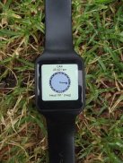
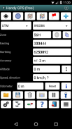
* आपके वर्तमान निर्देशांक, ऊंचाई, गति, यात्रा की दिशा और मीट्रिक, शाही/यूएस, या समुद्री इकाइयों में तय की गई कुल दूरी दिखाता है।
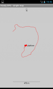
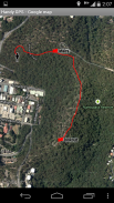
* आपके वर्तमान स्थान को एक मार्ग बिंदु के रूप में संग्रहीत कर सकता है, और यह दिखाने के लिए ट्रैक लॉग रिकॉर्ड कर सकता है कि आप मानचित्र पर कहां हैं।
* डेटा को KML और GPX फ़ाइलों से आयात और निर्यात किया जा सकता है।
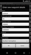
* यूटीएम, एमजीआरएस और लैट/लोन कोर्डर्स में वेपॉइंट की मैन्युअल प्रविष्टि की अनुमति देता है।
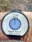
* "गोटो" स्क्रीन का उपयोग करके आपको एक मार्ग बिंदु पर मार्गदर्शन कर सकता है, और जब आप करीब आ रहे हों तो वैकल्पिक रूप से एक अलर्ट ध्वनि कर सकता है।
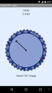
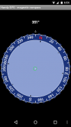
* इसमें एक कंपास पृष्ठ है जो चुंबकीय क्षेत्र सेंसर वाले उपकरणों पर काम करता है।
* ऊंचाई सटीकता में सुधार के लिए स्वचालित रूप से स्थानीय जियोइड ऑफसेट की गणना करता है
* सामान्य ऑस्ट्रेलियाई डेटाम और मानचित्र ग्रिड के साथ-साथ विश्वव्यापी WGS84 डेटाम का समर्थन करता है। आप यूएस में NAD83 मानचित्रों के लिए WGS84 का उपयोग कर सकते हैं।
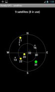
* जीपीएस उपग्रह स्थानों और सिग्नल की शक्तियों को ग्राफ़िक रूप से दिखाता है।
* सरल या एमजीआरएस ग्रिड संदर्भ प्रदर्शित कर सकते हैं।
* वेपॉइंट-टू-वेपॉइंट दूरी और दिशा की गणना कर सकता है।
* चलने की अवधि रिकॉर्ड करने और आपकी औसत गति की गणना करने के लिए एक वैकल्पिक टाइमर लाइन शामिल है।
* कई ऑफ-ट्रैक वॉक पर डेवलपर द्वारा पूरी तरह से परीक्षण किया गया
अतिरिक्त सुविधाएँ केवल भुगतान किए गए संस्करण में:
* विज्ञापन नहीं।
* असीमित संख्या में वेपॉइंट और ट्रैक लॉग पॉइंट।
* ऑफ़लाइन मानचित्र।
* कस्टम डाटाम्स।
* ऊंचाई प्रोफ़ाइल।
* ऐप से तस्वीरें लें और वॉयस मेमो रिकॉर्ड करें।
* किसी मित्र को अपना स्थान ईमेल या एसएमएस करें।
* यूके ग्रिड रेफरी।
* स्थान सटीकता में सुधार के लिए जीपीएस औसत,
*सूर्योदय और अस्त का समय।
* सीएसवी फ़ाइल में वेपॉइंट और ट्रैकलॉग निर्यात करें।
* बेयरिंग और दूरी का उपयोग करके वेपॉइंट प्रोजेक्ट करें।
* ट्रैकलॉग से लंबाई, क्षेत्रफल और ऊंचाई परिवर्तन की गणना करें।
* कैलोरी की गणना करें.
अनुमतियाँ: (1) जीपीएस - आपका स्थान निर्धारित करने के लिए, (2) नेटवर्क एक्सेस - मानक मानचित्र परतों और ओएसएम टाइल्स तक पहुंच के लिए, (3) एसडी कार्ड एक्सेस - वेपॉइंट और ट्रैकलॉग को लोड और स्टोर करने के लिए, (4) लेने के लिए कैमरा एक्सेस तस्वीरें*, (5) फोन को निष्क्रिय होने से रोकें ताकि निकटता अलार्म काम करे, (6) ऐप के भीतर से फ्लैशलाइट को चालू/बंद करने की अनुमति देने के लिए फ्लैशलाइट को नियंत्रित करें, (7) वॉयस मेमो के लिए ऑडियो रिकॉर्ड करें*। (* सुविधा केवल ऐप के पूर्ण संस्करण में उपलब्ध है)।
अस्वीकरण: आप इस ऐप का उपयोग अपने जोखिम पर करते हैं। इस ऐप के उपयोग के परिणामस्वरूप आपके खो जाने या घायल होने पर डेवलपर कोई ज़िम्मेदारी स्वीकार नहीं करता है। मोबाइल उपकरणों की बैटरियाँ ख़राब हो सकती हैं। विस्तारित और दूरस्थ पदयात्रा के लिए, सुरक्षा के लिए एक बैटरी बैंक और नेविगेशन की एक वैकल्पिक विधि जैसे पेपर मैप और कंपास की सिफारिश की जाती है।
Handy GPS lite - Version 42.8
(21-11-2024)
Handy GPS lite - एपीके जानकारी
एपीके संस्करण: 42.8पैकेज: binaryearth.handygpsfreeLatest Version of Handy GPS lite
अन्य संस्करण


Apps in the same category


